
Carte topographique Presidio County
Carte interactive
Cliquez sur la carte pour afficher l’altitude.
À propos de cette carte
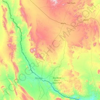
Nom : Carte topographique Presidio County, altitude, relief.
Lieu : Presidio County, Texas, United States of America (29.25837 -104.98075 30.62940 -103.79246)
Altitude moyenne : 1 255 m
Altitude minimum : 716 m
Altitude maximum : 2 348 m
Geographically, Presidio County comprises 3,857 square miles (9,990 km2) of contrasting topography, geology, and vegetation. In the north and west, clay and sandy loam cover the rolling plains known as the Marfa Plateau and the Highland Country, providing good ranges of grama grasses for the widely acclaimed Highland Herefords. In the central, far western, and southeastern areas of the county, some of the highest mountain ranges in Texas are found. These peaks are formed of volcanic rock and covered with loose surface rubble. They support desert shrubs and cacti and dominate a landscape of rugged canyons and numerous springs. The spring-fed Capote Falls, with a drop of 175 feet (53 m), the highest in Texas, is located in western Presidio County. In the southern and western parts of the county, the volcanic cliffs of the Candelaria Rimrock (also called the Sierra Vieja) rise perpendicular and run parallel to the river, separating the highland prairies from the desert floor hundreds of feet below them. The gravel pediment, which allows only the growth of desert shrubs and cacti, extends from the Rimrock to the flood plain of the river. Along the river, irrigation allows the farming of vegetables, grains, and cotton. No permanent streams exist in the county, although many arroyos become raging torrents during heavy rainfalls. Major ones are Alamito Creek, Cibolo Creek, Capote Creek, and Pinto Canyon. San Esteban Dam was built across Alamito Creek and on the site of a historic spring-fed tinaja in 1911 as an irrigation and land-promotion project. Altitudes in the county vary from 2,518 to 7,728 feet (767 to 2,355 m) above sea level. Temperatures, moderated by the mountains, vary from 33 °F (1 °C) in January to 100 °F (38 °C) in July. Average rainfall is 12 inches (300 mm) per year, mainly in June, July, and August. The growing season extends for 238 days. Natural resources under production in 1982 were perlite, crushed rhyolite, sand, and gravel. Silver mining contributed greatly to the economy of the county from the 1880s to the 1940s. Presidio County has no oil or gas production.
Autres cartes topographiques
Cliquez sur une carte pour visualiser sa topographie, son altitude et son relief.
Victoria County
United States of America > Texas
Victoria County, Texas, United States of America
Altitude moyenne : 31 m
Madison County
United States of America > Texas
Madison County, Texas, United States of America
Altitude moyenne : 91 m
Karnes County
United States of America > Texas
Karnes County, Texas, United States of America
Altitude moyenne : 114 m
Bolivar Peninsula
United States of America > Texas > Bolivar Peninsula
Bolivar Peninsula, Galveston County, Texas, 77652, United States of America
Altitude moyenne : 1 m
Morris County
United States of America > Texas
Morris County, Texas, United States of America
Altitude moyenne : 102 m
Sutton County
United States of America > Texas
Sutton County, Texas, United States of America
Altitude moyenne : 685 m
Houston County
United States of America > Texas
Houston County, Texas, United States of America
Altitude moyenne : 87 m
Pecos County
United States of America > Texas
Pecos County, Texas, United States of America
Altitude moyenne : 969 m
Lake Medina Highlands
United States of America > Texas > Lakehills > Lake Medina Highlands
Lake Medina Highlands, Lakehills, Bandera County, Texas, 78056, United States of America
Altitude moyenne : 344 m
Cameron County
United States of America > Texas
Cameron County, Texas, United States of America
Altitude moyenne : 6 m
El Paso County
United States of America > Texas
El Paso County, Texas, United States of America
Altitude moyenne : 1 267 m
Parker County
United States of America > Texas
Parker County, Texas, United States of America
Altitude moyenne : 297 m
Sun Valley
United States of America > Texas > Sun Valley
Sun Valley, Lamar County, Texas, United States of America
Altitude moyenne : 166 m
Newton County
United States of America > Texas
Newton County, Texas, United States of America
Altitude moyenne : 43 m
Fayette County
United States of America > Texas
Fayette County, Texas, United States of America
Altitude moyenne : 117 m
Leon County
United States of America > Texas
Leon County, Texas, United States of America
Altitude moyenne : 105 m
Daingerfield
United States of America > Texas > Daingerfield
Daingerfield, Morris County, Texas, 75638, United States of America
Altitude moyenne : 119 m
Shelby County
United States of America > Texas
Shelby County, Texas, United States of America
Altitude moyenne : 89 m
Duval County
United States of America > Texas
Duval County, Texas, United States of America
Altitude moyenne : 144 m
Washington County
United States of America > Texas
Washington County, Texas, United States of America
Altitude moyenne : 87 m
Montgomery County
United States of America > Texas
Montgomery County, Texas, United States of America
Altitude moyenne : 69 m
Mesquite
United States of America > Texas > Mesquite
Mesquite, Dallas County, Texas, United States of America
Altitude moyenne : 142 m
Missouri City
United States of America > Texas > Missouri City
Missouri City, Fort Bend County, Texas, United States of America
Altitude moyenne : 22 m
Spring Valley
United States of America > Texas > Spring Valley
Spring Valley, Harris County, Texas, United States of America
Altitude moyenne : 25 m
Seymour
United States of America > Texas > Seymour
Seymour, Baylor County, Texas, 76380, United States of America
Altitude moyenne : 401 m
Kent County
United States of America > Texas
Kent County, Texas, United States of America
Altitude moyenne : 646 m
King County
United States of America > Texas
King County, Texas, 79236, United States of America
Altitude moyenne : 540 m
Cedar Hill
United States of America > Texas > Cedar Hill
Cedar Hill, Dallas County, Texas, United States of America
Altitude moyenne : 214 m
Kenedy County
United States of America > Texas
Kenedy County, Texas, 78385, United States of America
Altitude moyenne : 12 m
Tarrant County
United States of America > Texas
Tarrant County, Texas, United States of America
Altitude moyenne : 211 m
Travis County
United States of America > Texas
Travis County, Texas, United States of America
Altitude moyenne : 231 m
Reeves County
United States of America > Texas
Reeves County, Texas, United States of America
Altitude moyenne : 986 m
Hays County
United States of America > Texas
Hays County, Texas, United States of America
Altitude moyenne : 285 m
Karnes City
United States of America > Texas > Karnes City
Karnes City, Karnes County, Texas, 78118, United States of America
Altitude moyenne : 122 m