
Carte topographique Ilam
Carte interactive
Cliquez sur la carte pour afficher l’altitude.
Ilam
The word ‘Ilam’ comprises two words-‘I’ and ‘Lam’. In Limbu language, the word ‘I’ means ‘winding’ and ‘lam’ denotes the way. The topography of this Ilam aptly depicts several winding paths crisscrossing.
À propos de cette carte
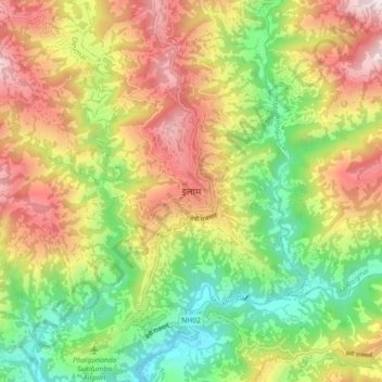
Nom : Carte topographique Ilam, altitude, relief.
Lieu : Ilam, Illam, Ilam, Koshi Province, 57300, Nepal (26.87039 87.88819 26.95039 87.96819)
Altitude moyenne : 919 m
Altitude minimum : 419 m
Altitude maximum : 1 522 m