
Carte topographique Baran
Cliquez sur la carte pour afficher l’altitude.
Baran
Baran is located at 25°06′N 76°31′E / 25.1°N 76.52°E / 25.1; 76.52. It has an average elevation of 262 metres (859 ft). It is surrounded by three Rivers Kalisindh, Parvati and Parban. The city is situated on the border of Rajasthan and Madhya Pradesh.
À propos de cette carte
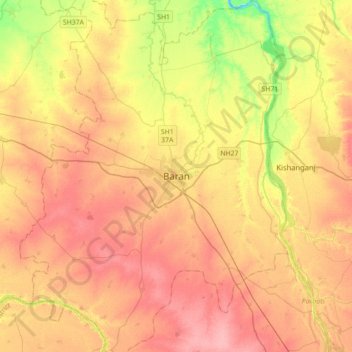
Nom : Carte topographique Baran, altitude, relief.
Lieu : Baran, Baran Tehsil, Baran District, Rajasthan, 325205, India (24.93819 76.35699 25.25819 76.67699)
Altitude moyenne : 264 m
Altitude minimum : 212 m
Altitude maximum : 300 m