
Carte topographique Long Ashton
Carte interactive
Cliquez sur la carte pour afficher l’altitude.
À propos de cette carte
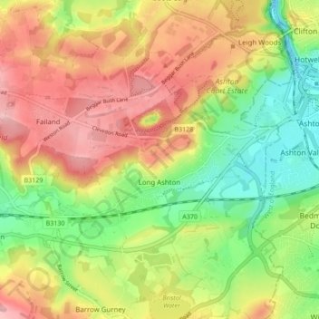
Nom : Carte topographique Long Ashton, altitude, relief.
Altitude moyenne : 82 m
Altitude minimum : -8 m
Altitude maximum : 166 m
Autres cartes topographiques
Cliquez sur une carte pour visualiser sa topographie, son altitude et son relief.
Yanley
United Kingdom > England > North Somerset > Long Ashton
Yanley, Long Ashton, North Somerset, England, BS41 9LR, United Kingdom
Altitude moyenne : 66 m