
Carte topographique Riffe Lake
Carte interactive
Cliquez sur la carte pour afficher l’altitude.
À propos de cette carte
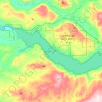
Nom : Carte topographique Riffe Lake, altitude, relief.
Lieu : Riffe Lake, Lewis County, Washington, United States (46.45667 -122.42651 46.53701 -122.16581)
Altitude moyenne : 503 m
Altitude minimum : 135 m
Altitude maximum : 1 179 m
Autres cartes topographiques
Cliquez sur une carte pour visualiser sa topographie, son altitude et son relief.
Ceres
United States > Washington > Lewis County
Ceres, Lewis County, Washington, United States
Altitude moyenne : 123 m
Toledo
United States > Washington > Lewis County
Toledo, Lewis County, Washington, United States
Altitude moyenne : 49 m
Mossyrock
United States > Washington > Lewis County
Mossyrock, Lewis County, Washington, United States
Altitude moyenne : 213 m
Ike Kinswa State Park
United States > Washington > Lewis County
Ike Kinswa State Park, Lewis County, Washington, United States
Altitude moyenne : 187 m
Chehalis
United States > Washington > Lewis County
Chehalis, Lewis County, Washington, United States
Altitude moyenne : 81 m
Centralia
United States > Washington > Lewis County
Centralia, Lewis County, Washington, United States
Altitude moyenne : 74 m
Winlock
United States > Washington > Lewis County
Winlock, Lewis County, Washington, United States
Altitude moyenne : 124 m
Ham Hill
United States > Washington > Lewis County > Centralia
Ham Hill, Centralia, Lewis County, Washington, United States
Altitude moyenne : 101 m
The Rockies
United States > Washington > Lewis County
The Rockies, Lewis County, Washington, United States
Altitude moyenne : 1 012 m
Napavine
United States > Washington > Lewis County > Napavine
Napavine, Lewis County, Washington, 98565, United States
Altitude moyenne : 105 m
Onalaska
United States > Washington > Lewis County
Onalaska, Lewis County, Washington, 98542, United States
Altitude moyenne : 170 m