
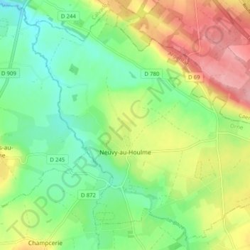
Carte topographique Neuvy-au-Houlme
Carte interactive
Cliquez sur la carte pour afficher l’altitude.
À propos de cette carte
Nom : Carte topographique Neuvy-au-Houlme, altitude, relief.
Altitude moyenne : 192 m
Altitude minimum : 145 m
Altitude maximum : 263 m
Autres cartes topographiques
Cliquez sur une carte pour visualiser sa topographie, son altitude et son relief.
Domfront en Poiraie
Domfront en Poiraie, Argentan, Orne, Normandy, Metropolitan France, 61700, France
Altitude moyenne : 174 m
Vimoutiers
Vimoutiers, Mortagne-au-Perche, Orne, Normandy, Metropolitan France, 61120, France
Altitude moyenne : 172 m
Chambois
France > Normandy > Orne > Gouffern en Auge
Chambois, Gouffern en Auge, Argentan, Orne, Normandy, Metropolitan France, 61160, France
Altitude moyenne : 115 m
Les Champeaux
Les Champeaux, Mortagne-au-Perche, Orne, Normandy, Metropolitan France, 61120, France
Altitude moyenne : 210 m
Les Courtils
France > Normandy > Orne > Putanges-le-Lac > Putanges-Pont-Écrepin
Les Courtils, Putanges-Pont-Écrepin, Putanges-le-Lac, Argentan, Orne, Normandy, Metropolitan France, 61210, France
Altitude moyenne : 186 m
La Ferté-Macé
France > Normandy > Orne > La Ferté-Macé
La Ferté-Macé, Argentan, Orne, Normandy, Metropolitan France, 61600, France
Altitude moyenne : 216 m
La Rouge
France > Normandy > Orne > Val-au-Perche
La Rouge, Val-au-Perche, Mortagne-au-Perche, Orne, Normandy, Metropolitan France, 61260, France
Altitude moyenne : 127 m