
Carte topographique Hargeisa
Carte interactive
Cliquez sur la carte pour afficher l’altitude.
À propos de cette carte
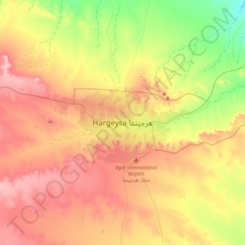
Nom : Carte topographique Hargeisa, altitude, relief.
Altitude moyenne : 1 289 m
Altitude minimum : 1 074 m
Altitude maximum : 1 516 m
Hargeisa is situated in a valley in the Galgodon (Ogo) highlands, and sits at an elevation of 1,334 m (4,377 ft). Home to rock art from the Neolithic period, the city is also a commercial hub for precious stone-cutting, construction, retail services and trading, among other activities.