
Carte topographique Crisfield
Carte interactive
Cliquez sur la carte pour afficher l’altitude.
À propos de cette carte
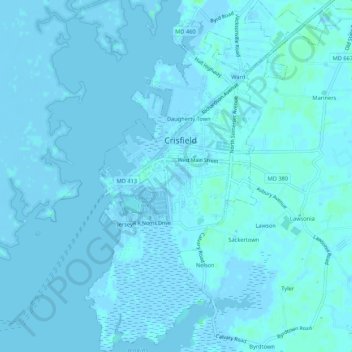
Nom : Carte topographique Crisfield, altitude, relief.
Lieu : Crisfield, Somerset County, Maryland, 21817, United States (37.95890 -75.87424 38.00094 -75.82563)
Altitude moyenne : 1 m
Altitude minimum : -4 m
Altitude maximum : 7 m
Crisfield is a very compact city, with little vacant land. According to the United States Census Bureau, the city has a total area of 3.06 square miles (7.93 km2), of which 1.62 square miles (4.20 km2) (53.0%) is land and 1.44 square miles (3.73 km2) (47.0%) is water. As one of the southern points on the Delmarva Peninsula and one very close to the Chesapeake Bay, the city is extremely flat, with the elevation never rising above 3 feet (0.91 m).
Autres cartes topographiques
Cliquez sur une carte pour visualiser sa topographie, son altitude et son relief.
Jersey Island
United States > Maryland > Somerset County > Crisfield
Jersey Island, Crisfield, Somerset County, Maryland, 21817, United States
Altitude moyenne : 2 m
Iverness
United States > Maryland > Somerset County
Iverness, Somerset County, Maryland, 21867, United States
Altitude moyenne : -1 m
Deal Island
United States > Maryland > Somerset County
Deal Island, Somerset County, Maryland, 21821, United States
Altitude moyenne : 2 m