
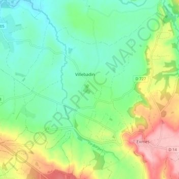
Carte topographique Villebadin
Carte interactive
Cliquez sur la carte pour afficher l’altitude.
À propos de cette carte
Nom : Carte topographique Villebadin, altitude, relief.
Altitude moyenne : 161 m
Altitude minimum : 107 m
Altitude maximum : 264 m
Autres cartes topographiques
Cliquez sur une carte pour visualiser sa topographie, son altitude et son relief.
La Barges
France > Normandie > Gouffern en Auge
La Barges, Gouffern en Auge, Argentan, Orne, Normandie, France métropolitaine, 61310, France
Altitude moyenne : 137 m