
Faire un don
Équipez-vous pour votre prochaine aventure :
En tant que Partenaire Amazon, ce site perçoit une commission sur les achats éligibles sans surcoût pour vous.
Carte topographique Texcoco de Mora
Cliquez sur la carte pour afficher l’altitude.
Faire un don
Équipez-vous pour votre prochaine aventure :
En tant que Partenaire Amazon, ce site perçoit une commission sur les achats éligibles sans surcoût pour vous.
Texcoco de Mora
Tescoco lies about 25 km east of the centre of Mexico City. Major elevations in the municipality include the Tlaloc Mountain (4,500 meters) the Tetzcutzinco, Moyotepec and Tecuachacho. Most elevations are named after the major community to be found on them. There are also a number of small canyons. Part of the municipality used to be covered by Lake Texcoco, but most of this lake has since been drained. The rivers that fed it, such as the Cozcacuaco, the Chapingo and the San Bernardino still exist.
Faire un don
Équipez-vous pour votre prochaine aventure :
En tant que Partenaire Amazon, ce site perçoit une commission sur les achats éligibles sans surcoût pour vous.
À propos de cette carte
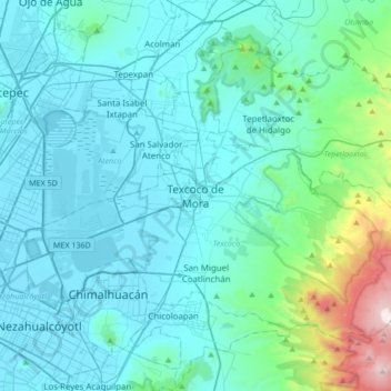
Nom : Carte topographique Texcoco de Mora, altitude, relief.
Lieu : Texcoco de Mora, Texcoco, State of Mexico, 56100, Mexico (19.35443 -99.04213 19.67443 -98.72213)
Altitude moyenne : 2 448 m
Altitude minimum : 2 223 m
Altitude maximum : 4 121 m
Faire un don
Équipez-vous pour votre prochaine aventure :
En tant que Partenaire Amazon, ce site perçoit une commission sur les achats éligibles sans surcoût pour vous.