
Carte topographique Lowrys Resurvey
Carte interactive
Cliquez sur la carte pour afficher l’altitude.
À propos de cette carte
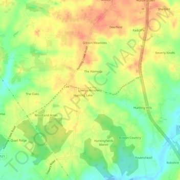
Nom : Carte topographique Lowrys Resurvey, altitude, relief.
Lieu : Lowrys Resurvey, Calvert County, Maryland, United States (38.57595 -76.64885 38.61595 -76.60885)
Altitude moyenne : 29 m
Altitude minimum : -2 m
Altitude maximum : 55 m
Autres cartes topographiques
Cliquez sur une carte pour visualiser sa topographie, son altitude et son relief.
Chesapeake Beach
United States > Maryland > Calvert County
Chesapeake Beach, Calvert County, Maryland, 20732, United States
Altitude moyenne : 6 m
North Beach
United States > Maryland > Calvert County
North Beach, Calvert County, Maryland, United States
Altitude moyenne : 6 m
Woodridge
United States > Maryland > Calvert County > Prince Frederick > Woodridge
Woodridge, Prince Frederick, Calvert County, Maryland, 20678, United States
Altitude moyenne : 37 m
Crow Haven Estates
United States > Maryland > Calvert County > Crow Haven Estates
Crow Haven Estates, Calvert County, Maryland, 21689, United States
Altitude moyenne : 34 m
Calvert County
United States > Maryland > Calvert County
Calvert County, Maryland, United States
Altitude moyenne : 18 m