
Carte topographique Aniakchak National Monument
Carte interactive
Cliquez sur la carte pour afficher l’altitude.
Aniakchak National Monument
The national monument is centered on the 6-mile (9.7 km) diameter crater of ancient Mount Aniakchak, which was destroyed and the resulting crater formed during a caldera collapse event about 3,700 years ago. The original mountain, about 7,000 feet (2,100 m) tall, collapsed into its magma chamber, leaving an approximate 3,300-foot (1,000 m) deep summit crater. (The elevation of the high point on the crater rim, Aniakchak Peak, is approximately 4,380 feet. The elevation of the low point of the caldera floor, at the mouth of Surprise Lake and the beginning of the Aniakchak River, is approximately 1,055 feet.) The monument and surrounding preserve include the volcanic feature, the wild Aniakchak River, the Bristol Bay coastal habitat, and portions of the coast of the Pacific Ocean.
À propos de cette carte
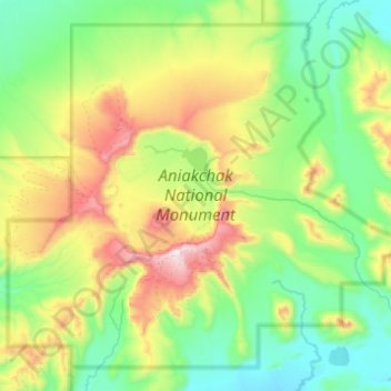
Nom : Carte topographique Aniakchak National Monument, altitude, relief.
Altitude moyenne : 376 m
Altitude minimum : 31 m
Altitude maximum : 1 321 m
Autres cartes topographiques
Cliquez sur une carte pour visualiser sa topographie, son altitude et son relief.