
Carte topographique Goodland
Carte interactive
Cliquez sur la carte pour afficher l’altitude.
Goodland
Goodland's climate is officially classed as humid continental (Koppen Dfa); although it only just misses a semi-arid (BSk) classification and is also close to a wet-summer continental climate (Dwa). Winters are generally cold and dry, summers hot and moderately wet. The average temperature for the year is 51 °F or 10.6 °C with temperatures exceeding 90 °F or 32.2 °C an average of fifty afternoons a year and dropping below 32 °F or 0 °C an average of 159 mornings a year. Due to its higher elevation, Goodland experiences stronger wind and higher snowfall totals than other locations in Kansas. Wind speed averages 13 mph (21 km/h). On average, Goodland receives 19.75 inches or 502 millimetres of precipitation annually, and snowfall averages 41.9 inches or 1.06 metres per year. On average, January is the coolest month, and July is both the warmest month and the wettest month. The hottest temperature recorded in Goodland was 111 °F or 43.9 °C in 1940; the coldest temperature recorded was −27 °F or −32.8 °C in 1989.
À propos de cette carte
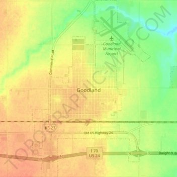
Nom : Carte topographique Goodland, altitude, relief.
Lieu : Goodland, Sherman County, Kansas, 67735, United States (39.32218 -101.73418 39.38030 -101.68377)
Altitude moyenne : 1 120 m
Altitude minimum : 1 097 m
Altitude maximum : 1 134 m