
Carte topographique Long Eaton
Carte interactive
Cliquez sur la carte pour afficher l’altitude.
À propos de cette carte
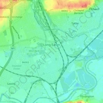
Nom : Carte topographique Long Eaton, altitude, relief.
Lieu : Long Eaton, Erewash, Derbyshire, England, United Kingdom (52.87329 -1.30594 52.91789 -1.23840)
Altitude moyenne : 35 m
Altitude minimum : 22 m
Altitude maximum : 75 m
Autres cartes topographiques
Cliquez sur une carte pour visualiser sa topographie, son altitude et son relief.
Ilkeston
United Kingdom > England > Derbyshire > Erewash > Ilkeston
Ilkeston, Erewash, Derbyshire, East Midlands, England, DE7 5JA, United Kingdom
Altitude moyenne : 81 m