
Carte topographique Chain Lakes
Carte interactive
Cliquez sur la carte pour afficher l’altitude.
À propos de cette carte
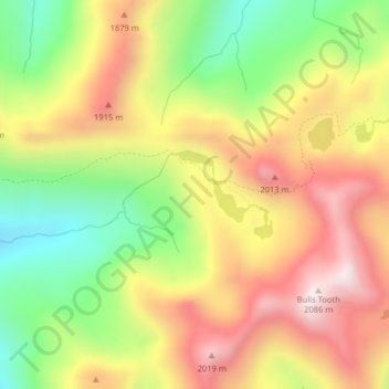
Nom : Carte topographique Chain Lakes, altitude, relief.
Lieu : Chain Lakes, Chelan County, Washington, United States (47.68542 -121.02166 47.69161 -121.01159)
Altitude moyenne : 1 697 m
Altitude minimum : 1 333 m
Altitude maximum : 2 051 m
Autres cartes topographiques
Cliquez sur une carte pour visualiser sa topographie, son altitude et son relief.
Leavenworth
United States > Washington > Chelan County
Leavenworth, Chelan County, Washington, United States
Altitude moyenne : 418 m
Cashmere
United States > Washington > Chelan County
Cashmere, Chelan County, Washington, United States
Altitude moyenne : 298 m
Dagger Lake
United States > Washington > Chelan County
Dagger Lake, Chelan County, Washington, United States
Altitude moyenne : 1 845 m
Little Bear
United States > Washington > Chelan County
Little Bear, Chelan County, Washington, 98815, United States
Altitude moyenne : 807 m
Jay Peak
United States > Washington > Chelan County
Jay Peak, Chelan County, Washington, United States
Altitude moyenne : 1 829 m
Lake Louis
United States > Washington > Chelan County
Lake Louis, Chelan County, Washington, United States
Altitude moyenne : 1 325 m
Wenatchee
United States > Washington > Chelan County
Wenatchee, Chelan County, Washington, 98801, United States
Altitude moyenne : 302 m