
Carte topographique Gomoa Central District
Carte interactive
Cliquez sur la carte pour afficher l’altitude.
À propos de cette carte
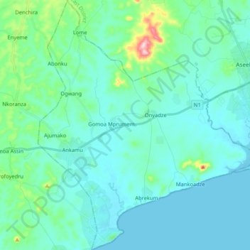
Nom : Carte topographique Gomoa Central District, altitude, relief.
Lieu : Gomoa Central District, Central Region, Ghana (5.27450 -0.78208 5.43434 -0.64240)
Altitude moyenne : 35 m
Altitude minimum : -1 m
Altitude maximum : 255 m
Autres cartes topographiques
Cliquez sur une carte pour visualiser sa topographie, son altitude et son relief.
Breman Asikuma
Ghana > Central Region > Asikuma/Odoben/Brakwa District
Breman Asikuma, Asikuma/Odoben/Brakwa District, Central Region, Ghana
Altitude moyenne : 85 m
Komenda
Ghana > Central Region > Komenda/Edina/Eguafo/Abirem Municipal District
Komenda, Komenda/Edina/Eguafo/Abirem Municipal District, Central Region, Ghana
Altitude moyenne : 5 m
Upper Denkyira West District
Upper Denkyira West District, Central Region, Ghana
Altitude moyenne : 142 m
Cape Coast
Ghana > Central Region > Cape Coast Metropolitan District
Cape Coast, Cape Coast Metropolitan District, Central Region, CC-008-3586, Ghana
Altitude moyenne : 22 m
Upper Denkyira East Municipal District
Ghana > Central Region > Upper Denkyira East Municipal District
Upper Denkyira East Municipal District, Central Region, Ghana
Altitude moyenne : 140 m
Awutu Breku
Ghana > Central Region > Awutu Senya West District
Awutu Breku, Awutu Senya West District, Central Region, Ghana
Altitude moyenne : 103 m
Kasoa
Ghana > Central Region > Gomoa East District
Kasoa, Gomoa East District, Central Region, Ghana
Altitude moyenne : 31 m
Elmina
Ghana > Central Region > Komenda/Edina/Eguafo/Abirem Municipal District
Elmina, Komenda/Edina/Eguafo/Abirem Municipal District, Central Region, Ghana
Altitude moyenne : 6 m
Awutu Bereku
Ghana > Central Region > Awutu Senya West District
Awutu Bereku, Awutu Senya West District, Central Region, Ghana
Altitude moyenne : 57 m