Géolocaliser

Carte topographique Junagadh

Cliquez sur la carte pour afficher l’altitude.

Junagadh

Junagadh city is located at 21°31′N 70°28′E / 21.52°N 70.47°E / 21.52; 70.47 at the foot of Mount Girnar, with the Arabian sea to the southwest, Porbandar to the north, and Amreli to the east. It has an average elevation of 107 metres (351 ft).

Wikipedia (CC-BY-SA 3.0)

À propos de cette carte

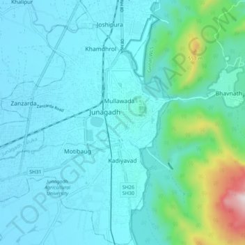
Nom : Carte topographique Junagadh, altitude, relief.

Lieu : Junagadh, Junagadh City Taluka, Junagadh, Gujarat, 362015, India (21.48828 70.39396 21.54876 70.47842)

Altitude moyenne : 163 m

Altitude minimum : 54 m

Altitude maximum : 853 m

Équipez-vous pour votre prochaine aventure :

👟Chaussures de Trail - Accroche maximale pour courir sur terrains techniques
🧢Bonnet en Laine Mérinos - Régulation thermique naturelle pour les nuits froides
🧴Gel Désinfectant Mains - Format voyage pour l'hygiène sur le terrain
🥤Sac d'Hydratation Trail - Système de boisson intégré pour un accès rapide sans s'arrêter
🔥Réchauds de camping - Réchauds compacts pour cuisine outdoor

En tant que Partenaire Amazon, ce site perçoit une commission sur les achats éligibles sans surcoût pour vous.