
Carte topographique Radzimów
Carte interactive
Cliquez sur la carte pour afficher l’altitude.
À propos de cette carte
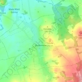
Nom : Carte topographique Radzimów, altitude, relief.
Altitude moyenne : 263 m
Altitude minimum : 220 m
Altitude maximum : 339 m
Autres cartes topographiques
Cliquez sur une carte pour visualiser sa topographie, son altitude et son relief.
Pop
Poland > Lower Silesian Voivodeship > Zgorzelec County > Studniska Dolne
Pop, Studniska Dolne, gmina Sulików, Zgorzelec County, Lower Silesian Voivodeship, 59-975, Poland
Altitude moyenne : 217 m
Bogatynia
Poland > Lower Silesian Voivodeship > Zgorzelec County
Bogatynia, gmina Bogatynia, Zgorzelec County, Lower Silesian Voivodeship, Poland
Altitude moyenne : 286 m