
Carte topographique Nantes Park
Carte interactive
Cliquez sur la carte pour afficher l’altitude.
À propos de cette carte
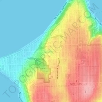
Nom : Carte topographique Nantes Park, altitude, relief.
Altitude moyenne : 53 m
Altitude minimum : -1 m
Altitude maximum : 131 m
Autres cartes topographiques
Cliquez sur une carte pour visualiser sa topographie, son altitude et son relief.
Queen Anne Hill
United States > Washington > King County > Seattle
Queen Anne Hill, Seattle, King County, Washington, 98109, United States
Altitude moyenne : 55 m
High Point
United States > Washington > King County > Seattle
High Point, Seattle, King County, Washington, 98126, United States
Altitude moyenne : 88 m
Licton Springs
United States > Washington > King County > Seattle
Licton Springs, Ashworth Avenue North, Licton Springs, Greenwood, Seattle, King County, Washington, 98113, United States
Altitude moyenne : 96 m
Lemur
United States > Washington > King County > Seattle
Lemur, Phinney Ridge, Seattle, King County, Washington, United States
Altitude moyenne : 59 m
Arbor Heights
United States > Washington > King County > Seattle > Arbor Heights
Arbor Heights, Seattle, King County, Washington, 98146, United States
Altitude moyenne : 60 m
Bitter Lake
United States > Washington > King County > Seattle > Bitter Lake
Bitter Lake, Seattle, King County, Washington, 98133, United States
Altitude moyenne : 112 m