
Carte topographique Jabal Ash Shaykh
Carte interactive
Cliquez sur la carte pour afficher l’altitude.
À propos de cette carte
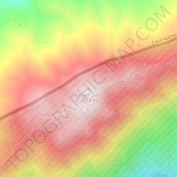
Nom : Carte topographique Jabal Ash Shaykh, altitude, relief.
Altitude moyenne : 2 516 m
Altitude minimum : 2 032 m
Altitude maximum : 2 813 m
Mount Hermon (Arabic: جبل الشيخ or جبل حرمون / ALA-LC: Jabal al-Shaykh ("Mountain of the Sheikh") or Jabal Haramun; Hebrew: הַר חֶרְמוֹן, Har Hermon) is a mountain cluster constituting the southern end of the Anti-Lebanon mountain range. Its summit straddles the border between Syria and Lebanon and, at 2,814 m (9,232 ft) above sea level, is the highest point in Syria. On the top, in the United Nations buffer zone between Syrian and Israeli-occupied territories, is the highest permanently manned UN position in the world, known as "Hermon Hotel", located at 2814 metres altitude. The southern slopes of Mount Hermon extend to the Israeli-occupied portion of the Golan Heights, where the Mount Hermon ski resort is located with a top elevation of 2,040 metres (6,690 ft). A peak in this area rising to 2,236 m (7,336 ft) is the highest elevation in Israeli-controlled territory.