
Faire un don
Équipez-vous pour votre prochaine aventure :
En tant que Partenaire Amazon, ce site perçoit une commission sur les achats éligibles sans surcoût pour vous.
Carte topographique Bawana
Cliquez sur la carte pour afficher l’altitude.
Faire un don
Équipez-vous pour votre prochaine aventure :
En tant que Partenaire Amazon, ce site perçoit une commission sur les achats éligibles sans surcoût pour vous.
Bawana
Bawana has an average elevation of 213 metres (698 feet). It is surrounded by the villages of Nangal Thakran, Bajitpur, Daryapur, Majra Dabas, Pooth Khurd, Holabmi Khurd, Kheda Khurd, Holambi Kalan, Sultanpur Dabas and Ghogha. The area of the village under farming was 52000 bigha, but now most of this land has been acquired by the Delhi Government for industrial use. Bawana, with its khadar soil, is very fertile, with a high water table due to the western Yamuna canal and the high density of ponds. The climate in the region is extreme, with very high temperatures in the summer and almost zero level temperatures in the winter months. J.J colony, a slum area inside Dilshad Colony, is separated from Bawana by a canal.
Faire un don
Équipez-vous pour votre prochaine aventure :
En tant que Partenaire Amazon, ce site perçoit une commission sur les achats éligibles sans surcoût pour vous.
À propos de cette carte
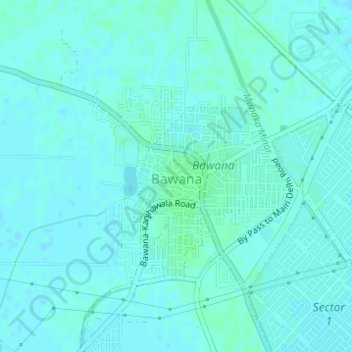
Nom : Carte topographique Bawana, altitude, relief.
Altitude moyenne : 219 m
Altitude minimum : 217 m
Altitude maximum : 223 m
Faire un don
Équipez-vous pour votre prochaine aventure :
En tant que Partenaire Amazon, ce site perçoit une commission sur les achats éligibles sans surcoût pour vous.