
Carte topographique Red Lodge
Carte interactive
Cliquez sur la carte pour afficher l’altitude.
À propos de cette carte
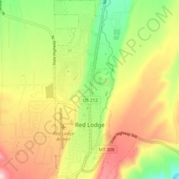
Nom : Carte topographique Red Lodge, altitude, relief.
Lieu : Red Lodge, Carbon County, Montana, 59068, United States (45.17150 -109.26051 45.21889 -109.23767)
Altitude moyenne : 1 720 m
Altitude minimum : 1 595 m
Altitude maximum : 1 850 m
Red Lodge experiences a continental climate (Köppen Dfb) with cold, somewhat dry winters and warm, wetter summers. Summers are cooler than in areas of Montana further north, due to the high elevation. Winters however, are milder than areas further to the east due to the chinook wind influence, as with most of Montana.