
Carte topographique Waischenfeld
Carte interactive
Cliquez sur la carte pour afficher l’altitude.
À propos de cette carte
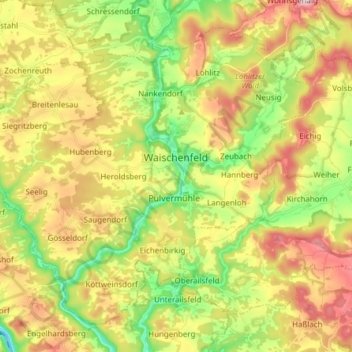
Nom : Carte topographique Waischenfeld, altitude, relief.
Lieu : Waischenfeld, Landkreis Bayreuth, Bavaria, 91344, Germany (49.79969 11.25670 49.88290 11.40954)
Altitude moyenne : 435 m
Altitude minimum : 309 m
Altitude maximum : 580 m
Autres cartes topographiques
Cliquez sur une carte pour visualiser sa topographie, son altitude et son relief.
95469
Germany > Bavaria > Landkreis Bayreuth > Kirchenlaibach
95469, Kirchenlaibach, Speichersdorf, Landkreis Bayreuth, Bavaria, Germany
Altitude moyenne : 464 m
Görschnitz
Germany > Bavaria > Landkreis Bayreuth > Weidenberg
Görschnitz, Weidenberg, Weidenberg (VGem), Landkreis Bayreuth, Bavaria, 95466, Germany
Altitude moyenne : 486 m
Pegnitz
Germany > Bavaria > Landkreis Bayreuth
Pegnitz, Landkreis Bayreuth, Bavaria, 91257, Germany
Altitude moyenne : 485 m
Gefrees
Germany > Bavaria > Landkreis Bayreuth
Gefrees, Landkreis Bayreuth, Bavaria, 95482, Germany
Altitude moyenne : 585 m