
Carte topographique Aegina
Carte interactive
Cliquez sur la carte pour afficher l’altitude.
À propos de cette carte
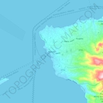
Nom : Carte topographique Aegina, altitude, relief.
Altitude moyenne : 27 m
Altitude minimum : -2 m
Altitude maximum : 365 m
Autres cartes topographiques
Cliquez sur une carte pour visualiser sa topographie, son altitude et son relief.
Methana
Greece > Attica > Regional Unit of Islands > Municipal Unit of Methana
Methana, Municipal Unit of Methana, Municipality of Troizinia - Methana, Regional Unit of Islands, Attica, 180 30, Greece
Altitude moyenne : 123 m
Lydia
Greece > Attica > Regional Unit of Islands
Lydia, Regional Unit of Islands, Attica, Greece
Altitude moyenne : 4 m
Ampelakia Municipal Unit
Greece > Attica > Regional Unit of Islands
Ampelakia Municipal Unit, Municipality of Salamina, Regional Unit of Islands, Attica, 189 02, Greece
Altitude moyenne : 55 m
Salamis
Greece > Attica > Regional Unit of Islands > Ampelakia Municipal Unit
Salamis, Ampelakia Municipal Unit, Municipality of Salamina, Regional Unit of Islands, Attica, Greece
Altitude moyenne : 38 m
Poros
Greece > Attica > Regional Unit of Islands > Poros
Poros, Municipality of Poros, Regional Unit of Islands, Attica, 180 20, Greece
Altitude moyenne : 31 m
Spetses
Greece > Attica > Regional Unit of Islands > Spetses
Spetses, Municipality of Spetses, Regional Unit of Islands, Attica, 180 50, Greece
Altitude moyenne : 33 m
Perani
Greece > Attica > Regional Unit of Islands > Salamina Municipal Unit
Perani, Salamina Municipal Unit, Municipality of Salamina, Regional Unit of Islands, Attica, 189 03, Greece
Altitude moyenne : 67 m
Aegina
Greece > Attica > Regional Unit of Islands > Kontos
Aegina, Kontos, Municipality of Aegina, Regional Unit of Islands, Attica, 180 10, Greece
Altitude moyenne : 60 m
Kythira
Greece > Attica > Regional Unit of Islands
Kythira, Regional Unit of Islands, Attica, Greece
Altitude moyenne : 75 m
Hydra
Greece > Attica > Regional Unit of Islands > Vlychos
Hydra, Vlychos, Municipality of Hydra, Regional Unit of Islands, Attica, 180 40, Greece
Altitude moyenne : 26 m