
Carte topographique Pampang
Carte interactive
Cliquez sur la carte pour afficher l’altitude.
À propos de cette carte
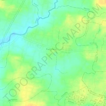
Nom : Carte topographique Pampang, altitude, relief.
Altitude moyenne : 166 m
Altitude minimum : 152 m
Altitude maximum : 180 m
Autres cartes topographiques
Cliquez sur une carte pour visualiser sa topographie, son altitude et son relief.
Tambakrejo
Indonesia > Special Region of Yogyakarta > Sleman Regency
Tambakrejo, Tempel, Sleman Regency, Special Region of Yogyakarta, Java, Indonesia
Altitude moyenne : 212 m
Karangasem
Indonesia > Special Region of Yogyakarta
Karangasem, Paliyan, Gunung Kidul Regency, Special Region of Yogyakarta, Indonesia
Altitude moyenne : 219 m
Trimurti
Indonesia > Special Region of Yogyakarta > Trimurti
Trimurti, Caturharjo, Pandak, Bantul Regency, Special Region of Yogyakarta, 55763, Indonesia
Altitude moyenne : 21 m
Bandung
Indonesia > Special Region of Yogyakarta
Bandung, Playen, Gunung Kidul Regency, Special Region of Yogyakarta, Indonesia
Altitude moyenne : 179 m