
Carte topographique Newbridge
Carte interactive
Cliquez sur la carte pour afficher l’altitude.
À propos de cette carte
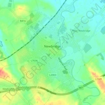
Nom : Carte topographique Newbridge, altitude, relief.
Altitude moyenne : 95 m
Altitude minimum : 79 m
Altitude maximum : 128 m
Autres cartes topographiques
Cliquez sur une carte pour visualiser sa topographie, son altitude et son relief.
Naas
Naas, The Municipal District of Naas, County Kildare, Leinster, Ireland
Altitude moyenne : 97 m
Collaghknock Glebe
Collaghknock Glebe, Kildare ED, The Municipal District of Kildare — Newbridge, County Kildare, Leinster, Ireland
Altitude moyenne : 103 m
Leixlip
Leixlip, The Municipal District of Celbridge — Leixlip, County Kildare, Leinster, Ireland
Altitude moyenne : 55 m
Newpark
Newpark, Kilmeage South ED, The Municipal District of Clane — Maynooth, County Kildare, Leinster, Ireland
Altitude moyenne : 87 m
Salt North
Salt North, County Kildare, Leinster, Ireland
Altitude moyenne : 67 m
Blackford
Blackford, Churchtown ED, The Municipal District of Athy, County Kildare, Leinster, Ireland
Altitude moyenne : 69 m
Naas
Ireland > County Kildare > Naas
Naas, The Municipal District of Naas, County Kildare, Leinster, Ireland
Altitude moyenne : 99 m
The Municipal District of Clane — Maynooth
The Municipal District of Clane — Maynooth, County Kildare, Leinster, Ireland
Altitude moyenne : 86 m
The Municipal District of Naas
The Municipal District of Naas, County Kildare, Leinster, Ireland
Altitude moyenne : 152 m