
Carte topographique Ahanta West Municipal District
Carte interactive
Cliquez sur la carte pour afficher l’altitude.
À propos de cette carte
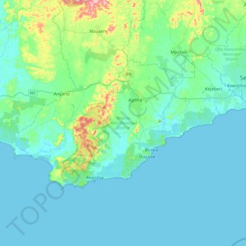
Nom : Carte topographique Ahanta West Municipal District, altitude, relief.
Lieu : Ahanta West Municipal District, Western Region, Ghana (4.73934 -2.18126 4.96351 -1.76785)
Altitude moyenne : 28 m
Altitude minimum : -1 m
Altitude maximum : 198 m
Autres cartes topographiques
Cliquez sur une carte pour visualiser sa topographie, son altitude et son relief.
Tarkwa
Ghana > Western Region > Tarkwa-Nsuaem Municipal District
Tarkwa, Tarkwa-Nsuaem Municipal District, Western Region, Ghana
Altitude moyenne : 96 m
Half Assini
Ghana > Western Region > Jomoro Municipal District
Half Assini, Jomoro Municipal District, Western Region, Ghana
Altitude moyenne : 7 m
Huni Valley
Ghana > Western Region > Prestea-Huni Valley Municipal District
Huni Valley, Prestea-Huni Valley Municipal District, Western Region, Ghana
Altitude moyenne : 140 m
Busua
Ghana > Western Region > Ahanta West Municipal District
Busua, Ahanta West Municipal District, Western Region, Ghana
Altitude moyenne : 13 m
Asankrangwa
Ghana > Western Region > Amenfi West Municipal District > Asankrangwa
Asankrangwa, Amenfi West Municipal District, Western Region, POST OFFICE BOX 6, Ghana
Altitude moyenne : 107 m
Sekondi
Ghana > Western Region > Sekondi Takoradi Metropolitan District > Sekondi
Sekondi, Sekondi Takoradi Metropolitan District, Western Region, Ghana
Altitude moyenne : 13 m
Wassa Akropong
Ghana > Western Region > Wassa Akropong
Wassa Akropong, Western Region, Ghana
Altitude moyenne : 85 m
Takoradi
Ghana > Western Region > Sekondi Takoradi Metropolitan District
Takoradi, Sekondi Takoradi Metropolitan District, Western Region, Ghana
Altitude moyenne : 4 m
Shama
Ghana > Western Region > Shama District
Shama, Shama District, Western Region, Ghana
Altitude moyenne : 8 m
Mpohor
Ghana > Western Region > Mpohor District
Mpohor, Mpohor District, Western Region, Ghana
Altitude moyenne : 36 m