
Carte topographique Platteville
Carte interactive
Cliquez sur la carte pour afficher l’altitude.
À propos de cette carte
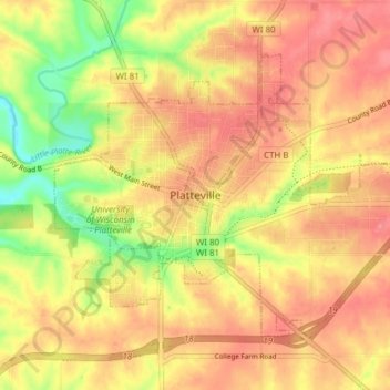
Nom : Carte topographique Platteville, altitude, relief.
Lieu : Platteville, Grant County, Wisconsin, 53818, United States (42.71397 -90.50631 42.75469 -90.42960)
Altitude moyenne : 295 m
Altitude minimum : 243 m
Altitude maximum : 327 m
Platteville is the largest city in Grant County, Wisconsin. The population was 11,836 at the 2020 census, up from 11,224 at the 2010 census. Much of this growth is likely due to the enrollment increase of the University of Wisconsin–Platteville. It is the principal city of the Platteville Micropolitan Statistical area, which has an estimated population of 51,938. Platteville is located atop the greater Platte River valley in the southern Driftless Region of Wisconsin, an area known for its karst topography and rolling hills.
Autres cartes topographiques
Cliquez sur une carte pour visualiser sa topographie, son altitude et son relief.
Blue River
United States > Wisconsin > Grant County
Blue River, Grant County, Wisconsin, United States
Altitude moyenne : 223 m
Potosi
United States > Wisconsin > Grant County
Potosi, Grant County, Wisconsin, United States
Altitude moyenne : 264 m
Town of Potosi
United States > Wisconsin > Grant County
Town of Potosi, Grant County, Wisconsin, 53820, United States
Altitude moyenne : 251 m