
Carte topographique Dunmore
Carte interactive
Cliquez sur la carte pour afficher l’altitude.
À propos de cette carte
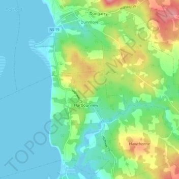
Nom : Carte topographique Dunmore, altitude, relief.
Altitude moyenne : 28 m
Altitude minimum : -1 m
Altitude maximum : 100 m
Autres cartes topographiques
Cliquez sur une carte pour visualiser sa topographie, son altitude et son relief.
Mabou Harbour
Canada > Nova Scotia > Municipality of the County of Inverness > West Mabou
Mabou Harbour, West Mabou, Municipality of the County of Inverness, Inverness County, Nova Scotia, Canada
Altitude moyenne : 51 m
Big Harbour Island
Canada > Nova Scotia > Municipality of the County of Inverness
Big Harbour Island, Municipality of the County of Inverness, Inverness County, Nova Scotia, Canada
Altitude moyenne : 3 m
Gull Island
Canada > Nova Scotia > Municipality of the County of Inverness > Big Harbour Island
Gull Island, Big Harbour Island, Municipality of the County of Inverness, Inverness County, Nova Scotia, Canada
Altitude moyenne : 74 m