
Carte topographique Newton Burgoland
Carte interactive
Cliquez sur la carte pour afficher l’altitude.
À propos de cette carte
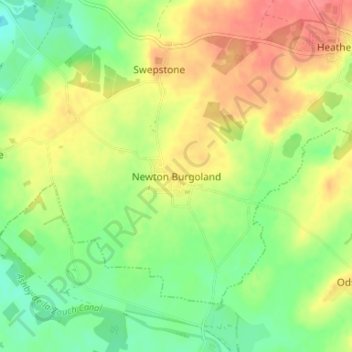
Nom : Carte topographique Newton Burgoland, altitude, relief.
Altitude moyenne : 109 m
Altitude minimum : 81 m
Altitude maximum : 140 m
Autres cartes topographiques
Cliquez sur une carte pour visualiser sa topographie, son altitude et son relief.
Blackfordby
United Kingdom > England > Leicestershire > North West Leicestershire > Blackfordby
Blackfordby, North West Leicestershire, Leicestershire, East Midlands, England, DE11 8AP, United Kingdom
Altitude moyenne : 135 m