Géolocaliser

Carte topographique Madawaska Highlands

Carte interactive

Cliquez sur la carte pour afficher l’altitude.

À propos de cette carte

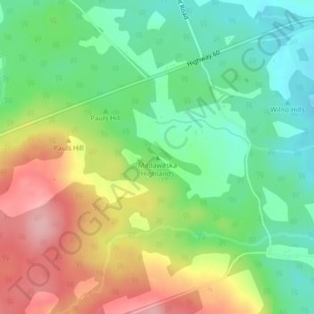
Nom : Carte topographique Madawaska Highlands, altitude, relief.

Lieu : Madawaska Highlands, Killaloe, Hagarty and Richards, Renfrew County, Eastern Ontario, Ontario, Canada (45.52397 -77.49133 45.52407 -77.49123)

Altitude moyenne : 272 m

Altitude minimum : 209 m

Altitude maximum : 364 m

Autres cartes topographiques

Cliquez sur une carte pour visualiser sa topographie, son altitude et son relief.

Bonnechere Provincial Park

Canada > Ontario > Renfrew County > Killaloe, Hagarty and Richards

Bonnechere Provincial Park, 4024, Round Lake Road, Killaloe, Hagarty and Richards, Renfrew County, Eastern Ontario, Ontario, L0S 1A0, Canada

Altitude moyenne : 174 m

Killaloe

Canada > Ontario > Renfrew County > Killaloe, Hagarty and Richards

Killaloe, Killaloe, Hagarty and Richards, Renfrew County, Eastern Ontario, Ontario, K0J 2A0, Canada

Altitude moyenne : 182 m