
Carte topographique Fremantle
Carte interactive
Cliquez sur la carte pour afficher l’altitude.
À propos de cette carte
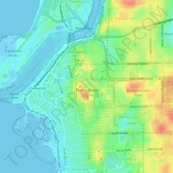
Nom : Carte topographique Fremantle, altitude, relief.
Lieu : Fremantle, City of Fremantle, Western Australia, Australia (-32.06394 115.73220 -32.04118 115.77973)
Altitude moyenne : 17 m
Altitude minimum : -10 m
Altitude maximum : 55 m
Autres cartes topographiques
Cliquez sur une carte pour visualiser sa topographie, son altitude et son relief.
Fremantle
Australia > Western Australia > City of Fremantle > Fremantle
Fremantle, City of Fremantle, Western Australia, 6959, Australia
Altitude moyenne : 11 m
Port Beach
Australia > Western Australia > City of Fremantle
Port Beach, North Fremantle, City of Fremantle, Western Australia, Australia
Altitude moyenne : 5 m
Beaconsfield
Australia > Western Australia > City of Fremantle
Beaconsfield, City of Fremantle, Western Australia, Australia
Altitude moyenne : 23 m
North Fremantle
Australia > Western Australia > City of Fremantle
North Fremantle, City of Fremantle, Western Australia, 6159, Australia
Altitude moyenne : 12 m
White Gum Valley
Australia > Western Australia > City of Fremantle
White Gum Valley, City of Fremantle, Western Australia, Australia
Altitude moyenne : 30 m
Hilton
Australia > Western Australia > City of Fremantle
Hilton, City of Fremantle, Western Australia, 6183, Australia
Altitude moyenne : 38 m
South Fremantle
Australia > Western Australia > City of Fremantle
South Fremantle, City of Fremantle, Western Australia, 6162, Australia
Altitude moyenne : 9 m
Round House
Australia > Western Australia > City of Fremantle > Fremantle
Round House, 15, Captains Lane, Fremantle, City of Fremantle, Western Australia, 6160, Australia
Altitude moyenne : 4 m