
Faire un don
Équipez-vous pour votre prochaine aventure :
En tant que Partenaire Amazon, ce site perçoit une commission sur les achats éligibles sans surcoût pour vous.
Carte topographique North Dighton
Cliquez sur la carte pour afficher l’altitude.
Faire un don
Équipez-vous pour votre prochaine aventure :
En tant que Partenaire Amazon, ce site perçoit une commission sur les achats éligibles sans surcoût pour vous.
À propos de cette carte
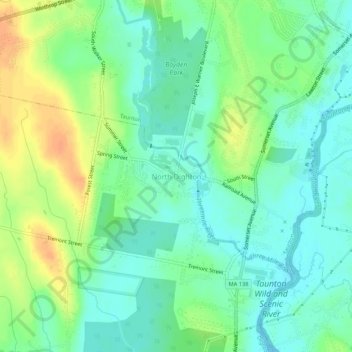
Nom : Carte topographique North Dighton, altitude, relief.
Altitude moyenne : 14 m
Altitude minimum : -1 m
Altitude maximum : 36 m
Faire un don
Équipez-vous pour votre prochaine aventure :
En tant que Partenaire Amazon, ce site perçoit une commission sur les achats éligibles sans surcoût pour vous.
Autres cartes topographiques
Cliquez sur une carte pour visualiser sa topographie, son altitude et son relief.
Taunton
United States > Massachusetts > Bristol County
Taunton has one major river, the Taunton River, along with its tributaries, including the Mill River and the Three Mile River. The highest point in the city is near its southwest corner, with an elevation of 207 feet (63 m) above sea level. Prospect Hill, rising over Lake Sabbatia north of the downtown, has an…
Altitude moyenne : 22 m
New Bedford
United States > Massachusetts > Bristol County
New Bedford is located at 41°39′06″N 70°56′01″W / 41.651803°N 70.933705°W / 41.651803; -70.933705 (41.651803, −70.933705). According to the United States Census Bureau, the city has a total area of 24.1 square miles (62.5 km2). Of the total area, 20.0 square miles (51.8 km2) is land, and…
Altitude moyenne : 21 m
Faire un don
Équipez-vous pour votre prochaine aventure :
En tant que Partenaire Amazon, ce site perçoit une commission sur les achats éligibles sans surcoût pour vous.
Fall River
United States > Massachusetts > Bristol County
Fall River was the only city on the East Coast of the United States to have had an exposed waterfall in part of its downtown area; it flowed less than 1⁄2 mile (0.8 km) into a sheltered harbor at the edge of downtown. Fall River has two large lakes (originally one lake) and a large portion of protected…
Altitude moyenne : 32 m
Dartmouth
United States > Massachusetts > Bristol County
The highest point in the town is near its northwest corner, where the elevation rises to over 256 feet (78 m) above sea level north of Old Fall River Road.
Altitude moyenne : 21 m
Faire un don
Équipez-vous pour votre prochaine aventure :
En tant que Partenaire Amazon, ce site perçoit une commission sur les achats éligibles sans surcoût pour vous.
Leonard and Marydee Flynn Cons Area
United States > Massachusetts > Bristol County > Mansfield
Altitude moyenne : 39 m
Acushnet
United States > Massachusetts > Bristol County
Acushnet lies along the Acushnet River and its tributaries, including the Keene River and Squinn Brook, which feed the New Bedford Reservoir, in turn feeding the Acushnet. The Acushnet River is the town line between it and New Bedford south of Main Street. There are several other ponds in the town, including…
Altitude moyenne : 21 m
Faire un don
Équipez-vous pour votre prochaine aventure :
En tant que Partenaire Amazon, ce site perçoit une commission sur les achats éligibles sans surcoût pour vous.
Faire un don
Équipez-vous pour votre prochaine aventure :
En tant que Partenaire Amazon, ce site perçoit une commission sur les achats éligibles sans surcoût pour vous.
New Bedford
United States > Massachusetts > Bristol County
New Bedford is located at 41°39′06″N 70°56′01″W / 41.651803°N 70.933705°W / 41.651803; -70.933705 (41.651803, −70.933705). According to the United States Census Bureau, the city has a total area of 24.1 square miles (62.5 km2). Of the total area, 20.0 square miles (51.8 km2) is land, and…
Altitude moyenne : 21 m
Fall River
United States > Massachusetts > Bristol County
Fall River was the only city on the East Coast of the United States to have had an exposed waterfall in part of its downtown area; it flowed less than 1⁄2 mile (0.8 km) into a sheltered harbor at the edge of downtown. Fall River has two large lakes (originally one lake) and a large portion of protected…
Altitude moyenne : 32 m
Faire un don
Équipez-vous pour votre prochaine aventure :
En tant que Partenaire Amazon, ce site perçoit une commission sur les achats éligibles sans surcoût pour vous.
Dighton
United States > Massachusetts > Bristol County
Dighton is bordered by Rehoboth to the west, Swansea to the southwest, Somerset to the south, the Taunton River and the town of Berkley to the east, and the city of Taunton to the north. In addition to being bordered by the Taunton River, it also is bordered by the Three Mile River, a tributary which empties…
Altitude moyenne : 18 m
New Bedford
United States > Massachusetts > Bristol County
New Bedford is located at 41°39′06″N 70°56′01″W / 41.651803°N 70.933705°W / 41.651803; -70.933705 (41.651803, −70.933705). According to the United States Census Bureau, the city has a total area of 24.1 square miles (62.5 km2). Of the total area, 20.0 square miles (51.8 km2) is land, and…
Altitude moyenne : 21 m
Faire un don
Équipez-vous pour votre prochaine aventure :
En tant que Partenaire Amazon, ce site perçoit une commission sur les achats éligibles sans surcoût pour vous.
Acushnet
United States > Massachusetts > Bristol County
Acushnet lies along the Acushnet River and its tributaries, including the Keene River and Squinn Brook, which feed the New Bedford Reservoir, in turn feeding the Acushnet. The Acushnet River is the town line between it and New Bedford south of Main Street. There are several other ponds in the town, including…
Altitude moyenne : 21 m
East Branch Westport River
United States > Massachusetts > Bristol County > Westport
Altitude moyenne : 24 m
Faire un don
Équipez-vous pour votre prochaine aventure :
En tant que Partenaire Amazon, ce site perçoit une commission sur les achats éligibles sans surcoût pour vous.
Taunton
United States > Massachusetts > Bristol County
Taunton has one major river, the Taunton River, along with its tributaries, including the Mill River and the Three Mile River. The highest point in the city is near its southwest corner, with an elevation of 207 feet (63 m) above sea level. Prospect Hill, rising over Lake Sabbatia north of the downtown, has an…
Altitude moyenne : 21 m
Stetson-Piney Island Reserve
United States > Massachusetts > Bristol County > Dartmouth > Great Neck
Altitude moyenne : 0 m
Faire un don
Équipez-vous pour votre prochaine aventure :
En tant que Partenaire Amazon, ce site perçoit une commission sur les achats éligibles sans surcoût pour vous.
Source Is Shapefile From Town
United States > Massachusetts > Bristol County > Mansfield > Robinsonville
Altitude moyenne : 50 m
Faire un don
Équipez-vous pour votre prochaine aventure :
En tant que Partenaire Amazon, ce site perçoit une commission sur les achats éligibles sans surcoût pour vous.
Dartmouth
United States > Massachusetts > Bristol County
The highest point in the town is near its northwest corner, where the elevation rises to over 256 feet (78 m) above sea level north of Old Fall River Road.
Altitude moyenne : 21 m
Faire un don
Équipez-vous pour votre prochaine aventure :
En tant que Partenaire Amazon, ce site perçoit une commission sur les achats éligibles sans surcoût pour vous.
Source Is Shapefile From Town
United States > Massachusetts > Bristol County > Mansfield > Robinsonville
Altitude moyenne : 50 m
Faire un don
Équipez-vous pour votre prochaine aventure :
En tant que Partenaire Amazon, ce site perçoit une commission sur les achats éligibles sans surcoût pour vous.