
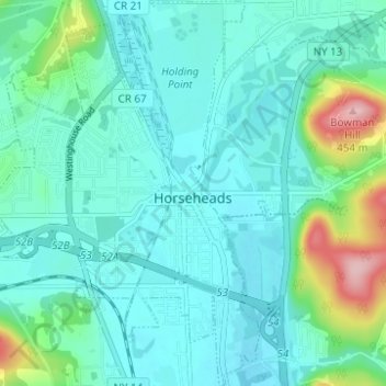
Carte topographique Village of Horseheads
Carte interactive
Cliquez sur la carte pour afficher l’altitude.
À propos de cette carte
Nom : Carte topographique Village of Horseheads, altitude, relief.
Altitude moyenne : 298 m
Altitude minimum : 263 m
Altitude maximum : 454 m
Autres cartes topographiques
Cliquez sur une carte pour visualiser sa topographie, son altitude et son relief.
West Elmira
United States > New York > Chemung County
West Elmira, Town of Elmira, Chemung County, New York, 14905, United States
Altitude moyenne : 320 m
Brand Park
United States > New York > Chemung County > City of Elmira
Brand Park, City of Elmira, Chemung County, New York, United States
Altitude moyenne : 270 m
City of Elmira
United States > New York > Chemung County > City of Elmira
City of Elmira, Ashland, Chemung County, New York, United States
Altitude moyenne : 296 m
Village of Millport
United States > New York > Chemung County
Village of Millport, Town of Veteran, Chemung County, New York, United States
Altitude moyenne : 296 m
Langdon Hill
United States > New York > Chemung County
Langdon Hill, Chemung County, New York, 14838, United States
Altitude moyenne : 449 m
Lowman
United States > New York > Chemung County
Lowman, Town of Ashland, Chemung County, New York, 14894, United States
Altitude moyenne : 290 m