
Carte topographique Orange Township
Carte interactive
Cliquez sur la carte pour afficher l’altitude.
À propos de cette carte
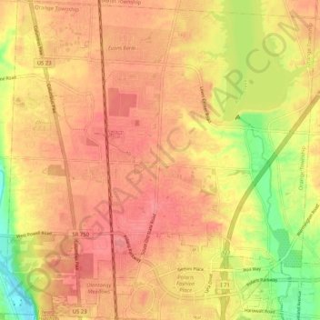
Nom : Carte topographique Orange Township, altitude, relief.
Lieu : Orange Township, Delaware County, Ohio, 43035, United States (40.13587 -83.04046 40.21402 -82.94164)
Altitude moyenne : 278 m
Altitude minimum : 232 m
Altitude maximum : 301 m
Autres cartes topographiques
Cliquez sur une carte pour visualiser sa topographie, son altitude et son relief.
Highbanks Metro Park
United States > Ohio > Delaware County > Columbus
Highbanks Metro Park, Columbus, Orange Township, Delaware County, Ohio, United States
Altitude moyenne : 272 m
Porter Township
United States > Ohio > Delaware County
Porter Township, Delaware County, Ohio, United States
Altitude moyenne : 340 m
Lewis Center
United States > Ohio > Delaware County
Lewis Center, Orange Township, Delaware County, Ohio, 43035, United States
Altitude moyenne : 286 m
Shawnee Hills
United States > Ohio > Delaware County
Shawnee Hills, Delaware County, Ohio, United States
Altitude moyenne : 271 m
Ostrander
United States > Ohio > Delaware County
Ostrander, Scioto Township, Delaware County, Ohio, United States
Altitude moyenne : 286 m
Radnor
United States > Ohio > Delaware County
Radnor, Radnor Township, Delaware County, Ohio, 43066, United States
Altitude moyenne : 284 m
Kilbourne
United States > Ohio > Delaware County
Kilbourne, Brown Township, Delaware County, Ohio, 43032, United States
Altitude moyenne : 289 m
Ashley
United States > Ohio > Delaware County
Ashley, Oxford Township, Delaware County, Ohio, United States
Altitude moyenne : 298 m
Concord Township
United States > Ohio > Delaware County
Concord Township, Delaware County, Ohio, United States
Altitude moyenne : 284 m
Berkshire
United States > Ohio > Delaware County
Berkshire, Berkshire Township, Delaware County, Ohio, 40321, United States
Altitude moyenne : 292 m
Galena
United States > Ohio > Delaware County
Galena, Berkshire Township, Delaware County, Ohio, United States
Altitude moyenne : 285 m
Sunbury
United States > Ohio > Delaware County
Sunbury, Delaware County, Ohio, United States
Altitude moyenne : 300 m
Center Green Park
United States > Ohio > Delaware County > Maxtown
Center Green Park, Maxtown, Genoa Township, Delaware County, Ohio, United States
Altitude moyenne : 277 m
Scioto
United States > Ohio > Delaware County > Scioto
Scioto, Scioto Township, Delaware County, Ohio, 43061, United States
Altitude moyenne : 282 m
Genoa Township
United States > Ohio > Delaware County
Genoa Township, Delaware County, Ohio, United States
Altitude moyenne : 281 m
Powell
United States > Ohio > Delaware County
Powell, Liberty Township, Delaware County, Ohio, United States
Altitude moyenne : 274 m
Delaware
United States > Ohio > Delaware County
Delaware, Delaware County, Ohio, 43015, United States
Altitude moyenne : 285 m