
Carte topographique Ninh Sơn District
Carte interactive
Cliquez sur la carte pour afficher l’altitude.
À propos de cette carte
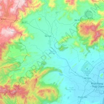
Nom : Carte topographique Ninh Sơn District, altitude, relief.
Lieu : Ninh Sơn District, Ninh Thuan province, Vietnam (11.49945 108.55166 11.92149 108.94593)
Altitude moyenne : 387 m
Altitude minimum : -1 m
Altitude maximum : 1 639 m
Autres cartes topographiques
Cliquez sur une carte pour visualiser sa topographie, son altitude et son relief.
Ninh Phước District
Ninh Phước District, Ninh Thuận Province, Vietnam
Altitude moyenne : 120 m
Phan Rang–Tháp Chàm City
Phan Rang–Tháp Chàm City, Ninh Thuận Province, Vietnam
Altitude moyenne : 13 m
Thuận Nam District
Thuận Nam District, Ninh Thuan province, Vietnam
Altitude moyenne : 150 m
Phan Rang - Tháp Chàm
Vietnam > Ninh Thuan province > Phan Rang - Tháp Chàm
Phan Rang - Tháp Chàm, Phan Rang–Tháp Chàm, Ninh Thuan province, Vietnam
Altitude moyenne : 65 m