
Faire un don
Équipez-vous pour votre prochaine aventure :
En tant que Partenaire Amazon, ce site perçoit une commission sur les achats éligibles sans surcoût pour vous.
Carte topographique Aventura
Cliquez sur la carte pour afficher l’altitude.
Faire un don
Équipez-vous pour votre prochaine aventure :
En tant que Partenaire Amazon, ce site perçoit une commission sur les achats éligibles sans surcoût pour vous.
Aventura
In addition to its sea-level elevation, coastal location and position just north of the Tropic of Cancer, the area owes its warm, humid climate to the Gulf Stream, which moderates climate year-round. A typical summer day does not see temperatures below 75 °F (24 °C). Temperatures in the high 80s to low 90s (30–35 °C) accompanied by high humidity are often relieved by afternoon thunderstorms or a sea breeze that develops off the Atlantic Ocean, which then allow lower temperatures, although conditions still remain very muggy. During winter, humidity is significantly lower, allowing for cooler weather to develop. Average minimum temperatures during that time are around 59 °F (15 °C), rarely dipping below 40 °F (4 °C), and the equivalent maxima usually around 75 °F (24 °C).
Faire un don
Équipez-vous pour votre prochaine aventure :
En tant que Partenaire Amazon, ce site perçoit une commission sur les achats éligibles sans surcoût pour vous.
À propos de cette carte
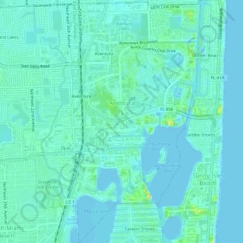
Nom : Carte topographique Aventura, altitude, relief.
Lieu : Aventura, Miami-Dade County, Florida, United States (25.93109 -80.15032 25.97505 -80.12331)
Altitude moyenne : 7 m
Altitude minimum : -2 m
Altitude maximum : 36 m
Faire un don
Équipez-vous pour votre prochaine aventure :
En tant que Partenaire Amazon, ce site perçoit une commission sur les achats éligibles sans surcoût pour vous.