
Faire un don
Équipez-vous pour votre prochaine aventure :
En tant que Partenaire Amazon, ce site perçoit une commission sur les achats éligibles sans surcoût pour vous.
Carte topographique Blake
Cliquez sur la carte pour afficher l’altitude.
Faire un don
Équipez-vous pour votre prochaine aventure :
En tant que Partenaire Amazon, ce site perçoit une commission sur les achats éligibles sans surcoût pour vous.
À propos de cette carte
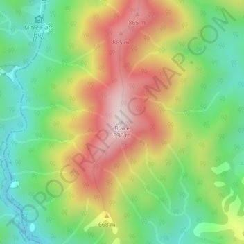
Nom : Carte topographique Blake, altitude, relief.
Lieu : Blake, Masterton District, Wellington, New Zealand (-40.84198 175.49092 -40.84188 175.49102)
Altitude moyenne : 568 m
Altitude minimum : 308 m
Altitude maximum : 910 m
Faire un don
Équipez-vous pour votre prochaine aventure :
En tant que Partenaire Amazon, ce site perçoit une commission sur les achats éligibles sans surcoût pour vous.
Autres cartes topographiques
Cliquez sur une carte pour visualiser sa topographie, son altitude et son relief.
Spenmoor Street Reserve
New Zealand > Wellington > Wellington City > Wellington
Altitude moyenne : 151 m
Faire un don
Équipez-vous pour votre prochaine aventure :
En tant que Partenaire Amazon, ce site perçoit une commission sur les achats éligibles sans surcoût pour vous.
Miramar Peninsula
New Zealand > Wellington > Wellington City > Wellington
The peninsula is exposed to Wellington's prevailing northwest wind and the southerly wind. During southerly storms, big waves and swells batter the peninsula's rocky southern shore. The peninsula's topography, with its high ridges and small bays and coves, provides shelter from the wind in many places. On 15…
Altitude moyenne : 20 m
Faire un don
Équipez-vous pour votre prochaine aventure :
En tant que Partenaire Amazon, ce site perçoit une commission sur les achats éligibles sans surcoût pour vous.
Martinborough
New Zealand > Wellington > South Wairarapa District > Martinborough Community
Altitude moyenne : 34 m