
Faire un don
Équipez-vous pour votre prochaine aventure :
En tant que Partenaire Amazon, ce site perçoit une commission sur les achats éligibles sans surcoût pour vous.
Carte topographique Baoding City
Cliquez sur la carte pour afficher l’altitude.
Faire un don
Équipez-vous pour votre prochaine aventure :
En tant que Partenaire Amazon, ce site perçoit une commission sur les achats éligibles sans surcoût pour vous.
Baoding City
Elevations in Baoding's administrative area decrease from northwest to southeast. The western parts are dominated by mountains and hills that are generally more than 1,000 metres (3,300 ft) tall; this area includes parts of Laishui, Yi, Mancheng, Shunping, Tang and Fuping Counties as well as the entirety of Laiyuan County, occupying 30.6% of the prefecture's area. The highest peak is Mount Waitou (歪头山), with an elevation of 2,286 metres (7,500 ft). Moving southeast from this area, one encounters low-lying mountains and hills, taking up 18.9% of the prefecture's area. Further to the east lies generally flat terrain of 30 to 100 metres (98 to 330 ft) elevation. Here the primary rivers are the Juma, Yishui (易水), Cao (漕河), Longquan (龙泉河), Tang (唐河), and Sha Rivers. Baiyangdian Lake, the largest natural lake in northern China, can be found nearby.
Faire un don
Équipez-vous pour votre prochaine aventure :
En tant que Partenaire Amazon, ce site perçoit une commission sur les achats éligibles sans surcoût pour vous.
À propos de cette carte
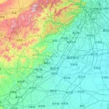
Nom : Carte topographique Baoding City, altitude, relief.
Lieu : Baoding City, Hebei, China (38.23222 113.75995 39.95120 116.24213)
Altitude moyenne : 338 m
Altitude minimum : 2 m
Altitude maximum : 2 805 m
Faire un don
Équipez-vous pour votre prochaine aventure :
En tant que Partenaire Amazon, ce site perçoit une commission sur les achats éligibles sans surcoût pour vous.
Autres cartes topographiques
Cliquez sur une carte pour visualiser sa topographie, son altitude et son relief.
Faire un don
Équipez-vous pour votre prochaine aventure :
En tant que Partenaire Amazon, ce site perçoit une commission sur les achats éligibles sans surcoût pour vous.
Faire un don
Équipez-vous pour votre prochaine aventure :
En tant que Partenaire Amazon, ce site perçoit une commission sur les achats éligibles sans surcoût pour vous.
Faire un don
Équipez-vous pour votre prochaine aventure :
En tant que Partenaire Amazon, ce site perçoit une commission sur les achats éligibles sans surcoût pour vous.
Faire un don
Équipez-vous pour votre prochaine aventure :
En tant que Partenaire Amazon, ce site perçoit une commission sur les achats éligibles sans surcoût pour vous.
Faire un don
Équipez-vous pour votre prochaine aventure :
En tant que Partenaire Amazon, ce site perçoit une commission sur les achats éligibles sans surcoût pour vous.
Faire un don
Équipez-vous pour votre prochaine aventure :
En tant que Partenaire Amazon, ce site perçoit une commission sur les achats éligibles sans surcoût pour vous.
Faire un don
Équipez-vous pour votre prochaine aventure :
En tant que Partenaire Amazon, ce site perçoit une commission sur les achats éligibles sans surcoût pour vous.