
Carte topographique Daphne
Carte interactive
Cliquez sur la carte pour afficher l’altitude.
Daphne
The topography of Daphne is quite consistent from a gently sloping sea level on the west to low rolling hills further east. Generally, the entire city lies no more than 150 feet above sea level. The land along the Daphne bay coast, like other land throughout the county, is rich with sandy-loam type soils.
À propos de cette carte
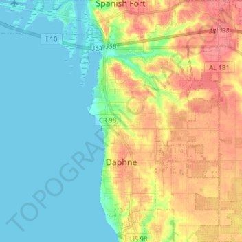
Nom : Carte topographique Daphne, altitude, relief.
Lieu : Daphne, Baldwin County, Alabama, United States (30.56903 -87.92237 30.67677 -87.84305)
Altitude moyenne : 25 m
Altitude minimum : -2 m
Altitude maximum : 65 m