
Carte topographique Nanjing City
Carte interactive
Cliquez sur la carte pour afficher l’altitude.
À propos de cette carte
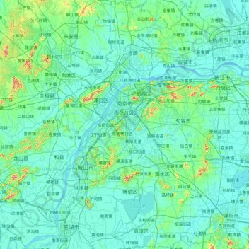
Nom : Carte topographique Nanjing City, altitude, relief.
Lieu : Nanjing City, Jiangsu, China (31.22675 118.33459 32.61578 119.23951)
Altitude moyenne : 28 m
Altitude minimum : -1 m
Altitude maximum : 418 m
There are mainly two types of soil in Nanjing: zonal soil and cultivated soil. The zonal soil is yellow-brown soil in the northern and central areas of Nanjing, and red soil in the southern part of the border with Anhui. The cultivated soil formed by human-made farming is mainly paddy soil, and there are some yellow Gang soil and vegetable garden soil. The distribution of soil presents a certain law with the undulation of topography and hydrological conditions, which can be divided into three categories: low mountain and hilly area, hilly area and plain area. According to the second national soil survey from 1980 to 1987, the soil in Nanjing is divided into 7 soil types, 13 subtypes, 30 soil genera and 66 soil species, with a total area of 416,300 hectares.
Autres cartes topographiques
Cliquez sur une carte pour visualiser sa topographie, son altitude et son relief.
Xinwu District
Xinwu District, Wuxi City, Jiangsu, 214000, China
Altitude moyenne : 7 m
Chongchuan District
Chongchuan District, Nantong, Jiangsu, 226000, China
Altitude moyenne : 3 m
Bagua Island
China > Jiangsu > Nanjing City
Bagua Island, Nanjing City, Jiangsu, China
Altitude moyenne : 7 m
Lianyungang City
China > Jiangsu > Lianyungang City
Lianyungang City, Jiangsu, China
Altitude moyenne : 19 m