
Carte topographique Lamayuru
Carte interactive
Cliquez sur la carte pour afficher l’altitude.
À propos de cette carte
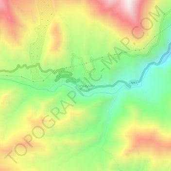
Nom : Carte topographique Lamayuru, altitude, relief.
Lieu : Lamayuru, Khalsi tehsil, Leh District, Ladakh, Inde (34.26271 76.75396 34.30271 76.79396)
Altitude moyenne : 3 691 m
Altitude minimum : 3 242 m
Altitude maximum : 4 228 m
Autres cartes topographiques
Cliquez sur une carte pour visualiser sa topographie, son altitude et son relief.
Ursi
Inde > Ladakh > Khalsi tehsil
Ursi, Khalsi tehsil, Leh District, Ladakh, Inde
Altitude moyenne : 3 941 m
Lingshed
Inde > Ladakh > Khalsi tehsil
Lingshed, Khalsi tehsil, Leh District, Ladakh, Inde
Altitude moyenne : 4 209 m
Uleytokpo
Inde > Ladakh > Khalsi tehsil
Uleytokpo, Khalsi tehsil, Leh District, Ladakh, Inde
Altitude moyenne : 3 361 m
Khaltse
Inde > Ladakh > Khalsi tehsil
Khaltse, Khalsi tehsil, Leh District, Ladakh, Inde
Altitude moyenne : 3 287 m