
Carte topographique Wisła
Carte interactive
Cliquez sur la carte pour afficher l’altitude.
À propos de cette carte
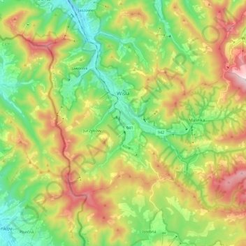
Nom : Carte topographique Wisła, altitude, relief.
Lieu : Wisła, Cieszyn County, Silesian Voivodeship, Poland (49.58533 18.80459 49.68626 19.01747)
Altitude moyenne : 651 m
Altitude minimum : 367 m
Altitude maximum : 1 094 m
Autres cartes topographiques
Cliquez sur une carte pour visualiser sa topographie, son altitude et son relief.
Istebna
Poland > Silesian Voivodeship > Cieszyn County
Istebna, gmina Istebna, Cieszyn County, Silesian Voivodeship, 43-470, Poland
Altitude moyenne : 662 m
Ustroń
Poland > Silesian Voivodeship > Cieszyn County > Ustroń
Ustroń, Cieszyn County, Silesian Voivodeship, 43-450, Poland
Altitude moyenne : 486 m
Jelenica
Poland > Silesian Voivodeship > Cieszyn County > Ustroń
Jelenica, Ustroń, Cieszyn County, Silesian Voivodeship, 43-450, Poland
Altitude moyenne : 441 m