
Carte topographique Refuge de Chaumailloux
Carte interactive
Cliquez sur la carte pour afficher l’altitude.
À propos de cette carte
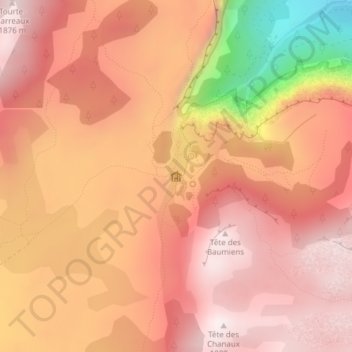
Nom : Carte topographique Refuge de Chaumailloux, altitude, relief.
Altitude moyenne : 1 652 m
Altitude minimum : 1 137 m
Altitude maximum : 1 880 m
Autres cartes topographiques
Cliquez sur une carte pour visualiser sa topographie, son altitude et son relief.
Tête Chevalière
France > Auvergne-Rhône-Alpes > Chichilianne
Tête Chevalière, Chichilianne, Grenoble, Isère, Auvergne-Rhône-Alpes, France métropolitaine, 38930, France
Altitude moyenne : 1 631 m
Pas de l'Aiguille
France > Auvergne-Rhône-Alpes > Chichilianne
Pas de l'Aiguille, Chichilianne, Grenoble, Isère, Auvergne-Rhône-Alpes, France métropolitaine, 38930, France
Altitude moyenne : 1 624 m
Gîte ONF du Pison
France > Auvergne-Rhône-Alpes > Chichilianne
Gîte ONF du Pison, GR91-93, Chichilianne, Grenoble, Isère, Auvergne-Rhône-Alpes, France métropolitaine, 38930, France
Altitude moyenne : 1 507 m