
Carte topographique Mallorytown Landing
Carte interactive
Cliquez sur la carte pour afficher l’altitude.
À propos de cette carte
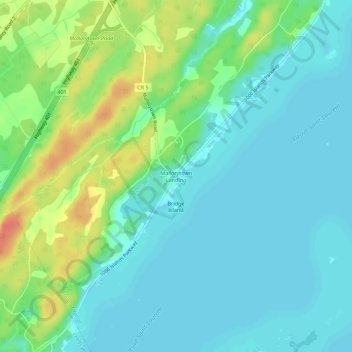
Nom : Carte topographique Mallorytown Landing, altitude, relief.
Altitude moyenne : 86 m
Altitude minimum : 72 m
Altitude maximum : 121 m
Autres cartes topographiques
Cliquez sur une carte pour visualiser sa topographie, son altitude et son relief.
Mallorytown
Canada > Ontario > Leeds and Grenville Counties > Front of Yonge
Mallorytown, Front of Yonge, Leeds and Grenville Counties, Eastern Ontario, Ontario, K0E 1R0, Canada
Altitude moyenne : 98 m