
Carte topographique Suti Semarang
Carte interactive
Cliquez sur la carte pour afficher l’altitude.
À propos de cette carte
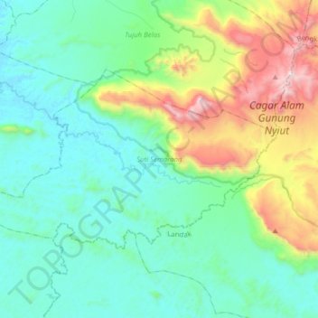
Nom : Carte topographique Suti Semarang, altitude, relief.
Lieu : Suti Semarang, Bengkayang, Kalimantan occidental, Indonésie (0.83200 109.60856 1.00754 109.91919)
Altitude moyenne : 378 m
Altitude minimum : 18 m
Altitude maximum : 1 639 m
Autres cartes topographiques
Cliquez sur une carte pour visualiser sa topographie, son altitude et son relief.
Pontianak
Indonésie > Kalimantan occidental
Pontianak, Kalimantan occidental, Kalimantan, Indonésie
Altitude moyenne : 4 m
Suti Semarang
Indonésie > Kalimantan occidental > Bengkayang
Suti Semarang, Bengkayang, Kalimantan occidental, Indonésie
Altitude moyenne : 101 m
Bangka Belitung Laut
Indonésie > Kalimantan occidental > Pontianak
Bangka Belitung Laut, Pontianak Tenggara, Pontianak, Kalimantan occidental, 78242, Indonésie
Altitude moyenne : 3 m
Sanggau
Indonésie > Kalimantan occidental > Sanggau
Sanggau, Kalimantan occidental, Indonésie
Altitude moyenne : 42 m
Jayawijaya
Indonésie > Kalimantan occidental
Jayawijaya, Kalimantan occidental, Indonésie
Altitude moyenne : 5 m