
Carte topographique Argostoli
Carte interactive
Cliquez sur la carte pour afficher l’altitude.
À propos de cette carte
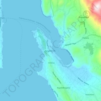
Nom : Carte topographique Argostoli, altitude, relief.
Altitude moyenne : 79 m
Altitude minimum : -1 m
Altitude maximum : 844 m
Autres cartes topographiques
Cliquez sur une carte pour visualiser sa topographie, son altitude et son relief.
Kefalonia
Greece > Peloponnese, Western Greece and the Ionian > Kefallonia Regional Unit
Kefalonia, Argostoli Municipality, Kefallonia Regional Unit, Ioanian Islands, Peloponnese, Western Greece and the Ionian, Greece
Altitude moyenne : 60 m
Pastra
Greece > Peloponnese, Western Greece and the Ionian > Kefallonia Regional Unit > Municipal Unit of Elios-Proni
Pastra, Municipal Unit of Elios-Proni, Argostoli Municipality, Kefallonia Regional Unit, Ioanian Islands, Peloponnese, Western Greece and the Ionian, 280 82, Greece
Altitude moyenne : 305 m
Cephalonia
Greece > Peloponnese, Western Greece and the Ionian > Kefallonia Regional Unit
Cephalonia, Kefallonia Regional Unit, Ioanian Islands, Peloponnese, Western Greece and the Ionian, Greece
Altitude moyenne : 138 m
Katelios
Greece > Peloponnese, Western Greece and the Ionian > Kefallonia Regional Unit > Municipal Unit of Elios-Proni > Kato Katelios > Katelios
Katelios, Kato Katelios, Municipal Unit of Elios-Proni, Argostoli Municipality, Kefallonia Regional Unit, Ioanian Islands, Peloponnese, Western Greece and the Ionian, 28082, Greece
Altitude moyenne : 180 m
Sami
Greece > Peloponnese, Western Greece and the Ionian > Kefallonia Regional Unit > Sami Municipal Unit
Sami, Sami Municipal Unit, Sami Municipality, Kefallonia Regional Unit, Ioanian Islands, Peloponnese, Western Greece and the Ionian, 280 80, Greece
Altitude moyenne : 200 m