
Carte topographique Košice
Carte interactive
Cliquez sur la carte pour afficher l’altitude.
À propos de cette carte
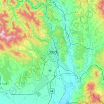
Nom : Carte topographique Košice, altitude, relief.
Lieu : Košice, Region of Košice, Eastern Slovakia, 04151, Slovakia (48.55723 21.08968 48.87723 21.40968)
Altitude moyenne : 350 m
Altitude minimum : 165 m
Altitude maximum : 1 082 m
Autres cartes topographiques
Cliquez sur une carte pour visualiser sa topographie, son altitude et son relief.
District of Košice I
Slovakia > Region of Košice > Košice
District of Košice I, Košice, Region of Košice, Eastern Slovakia, Slovakia
Altitude moyenne : 390 m