
Carte topographique Xochimilco
Carte interactive
Cliquez sur la carte pour afficher l’altitude.
À propos de cette carte
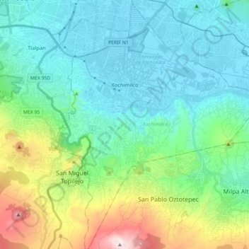
Nom : Carte topographique Xochimilco, altitude, relief.
Lieu : Xochimilco, Mexico City, Mexico (19.15254 -99.15439 19.32045 -99.00704)
Altitude moyenne : 2 513 m
Altitude minimum : 2 230 m
Altitude maximum : 3 495 m
Much of the borough's land is former lakebed. Its main elevations include Xochitepec and Tlacualleli mountains along with two volcanoes named Teutli and Tzompol. It contains two natural rivers called Santiago and Tepapantla along with the various canals, which is what is left of the lake. The elevated areas of the borough contain small forests of ocotes, strawberry trees, cedars, Montezuma cypress and a tree called a “tepozan.”
Autres cartes topographiques
Cliquez sur une carte pour visualiser sa topographie, son altitude et son relief.
Alameda Central
Alameda Central, Cuauhtémoc, Mexico City, Mexico
Altitude moyenne : 2 235 m
San Miguel Ajusco
San Miguel Ajusco, Mexico City, 14700, Mexico
Altitude moyenne : 2 939 m