
Carte topographique 杨梅渡公园
Carte interactive
Cliquez sur la carte pour afficher l’altitude.
À propos de cette carte
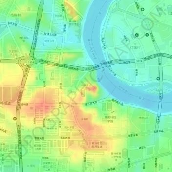
Nom : Carte topographique 杨梅渡公园, altitude, relief.
Lieu : 杨梅渡公园, 赣州经济技术开发区, 章贡区, 赣州市, 江西省, 中国 (25.84355 114.90590 25.84897 114.91338)
Altitude moyenne : 117 m
Altitude minimum : 93 m
Altitude maximum : 148 m
Autres cartes topographiques
Cliquez sur une carte pour visualiser sa topographie, son altitude et son relief.